
Thank you for supporting this site ❤️
Make a donation
Make a donation
La Grande Moucherolle topographic map
Click on the map to display elevation.
Thank you for supporting this site ❤️
Make a donation
Make a donation
La Grande Moucherolle
La Grande Moucherolle (2 284 mètres) est le deuxième sommet du massif du Vercors par son altitude. La Petite Moucherolle (2 156 mètres), légèrement plus au sud, est séparée de celle-ci par le col des Moucherolles.
Thank you for supporting this site ❤️
Make a donation
Make a donation
About this map
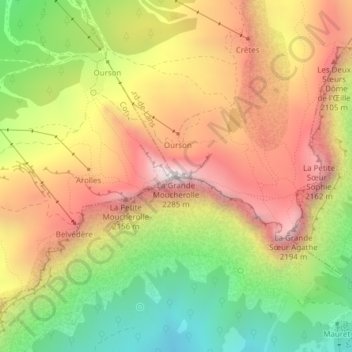
Name: La Grande Moucherolle topographic map, elevation, terrain.
Average elevation: 1,790 m
Minimum elevation: 1,263 m
Maximum elevation: 2,281 m
Thank you for supporting this site ❤️
Make a donation
Make a donation
Other topographic maps
Click on a map to view its topography, its elevation and its terrain.
Lac de la Moucherolle
France > Auvergne-Rhône-Alpes > Isère > Villard-de-Lans
Average elevation: 1,815 m