
Chappel topographic map
Interactive map
Click on the map to display elevation.
About this map
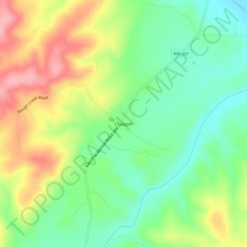
Name: Chappel topographic map, elevation, terrain.
Location: Chappel, San Saba County, Texas, United States (31.03573 -98.59087 31.07573 -98.55087)
Average elevation: 413 m
Minimum elevation: 361 m
Maximum elevation: 485 m
Other topographic maps
Click on a map to view its topography, its elevation and its terrain.
Mill Pond Park
United States > Texas > San Saba County > San Saba
Mill Pond Park, San Saba, San Saba County, Texas, United States
Average elevation: 377 m
San Saba
United States > Texas > San Saba County
San Saba, San Saba County, Texas, 76877, United States
Average elevation: 391 m
Skeeterville
United States > Texas > San Saba County
Skeeterville, San Saba County, Texas, United States
Average elevation: 423 m
Cherokee
United States > Texas > San Saba County
Cherokee, San Saba County, Texas, 76832, United States
Average elevation: 460 m
Harkeyville
United States > Texas > San Saba County
Harkeyville, San Saba County, Texas, United States
Average elevation: 376 m
Richland Springs
United States > Texas > San Saba County
Richland Springs, San Saba County, Texas, United States
Average elevation: 429 m
Bend
United States > Texas > San Saba County
Bend, San Saba County, Texas, United States
Average elevation: 350 m
China Creek
United States > Texas > San Saba County > China Creek
China Creek, San Saba County, Texas, United States
Average elevation: 394 m