
Make a donation
Kalgoorlie topographic map
Click on the map to display elevation.
Make a donation
About this map
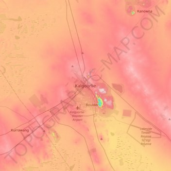
Name: Kalgoorlie topographic map, elevation, terrain.
Average elevation: 360 m
Minimum elevation: 184 m
Maximum elevation: 450 m
Make a donation
Other topographic maps
Click on a map to view its topography, its elevation and its terrain.
Ellenbrook
The suburb sits in the south-east corner of the Gnangara Mound, close to the Darling Scarp. Topographically, the majority of Ellenbrook's area sits between 40-50 metres above sea level on the mound, with parts of Coolamon and Malvern Springs situated on hills that reach peaks of 65 metres. The northern village…
Average elevation: 49 m
Make a donation
Make a donation
Henley Brook
Henley Brook is situated on the flood plains of the Swan River, with regularly occurring seasonal floods. Two ephemeral streams from the river - Henley Brook and St. Leonard's Creek - traverse the suburb. Henley Brook is in the north-east near Brockman Street, while St Leonards Creek traverses the centre of…
Average elevation: 28 m
Make a donation
Make a donation
Make a donation
Make a donation
Make a donation
Make a donation
Make a donation
Make a donation
Make a donation
Make a donation
Make a donation
Make a donation
Make a donation
Make a donation
Make a donation
Make a donation
Make a donation
Make a donation
Make a donation
Make a donation
The Vines
Topographically, The Vines sits on a gradual incline that descends towards the Ellen Brook valley. The west of the suburb sits at 30 metres above sea level, dropping to 20 metres in the east around the brook and the Sawpit Gully.
Average elevation: 27 m
Make a donation
Make a donation
Make a donation