
Faiões topographic map
Interactive map
Click on the map to display elevation.
About this map
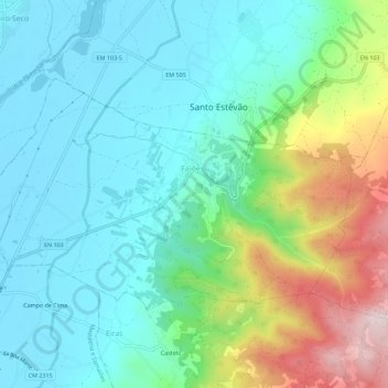
Name: Faiões topographic map, elevation, terrain.
Location: Faiões, Chaves, Vila Real, 5400-632, Portugal (41.73693 -7.45490 41.76206 -7.39852)
Average elevation: 455 m
Minimum elevation: 346 m
Maximum elevation: 766 m
Other topographic maps
Click on a map to view its topography, its elevation and its terrain.
Vegetação rípicola - Vale Fluvial do Corgo
Portugal > Vila Real > Chaves > Faiões
Vegetação rípicola - Vale Fluvial do Corgo, Faiões, Chaves, Vila Real, 5400-632, Portugal
Average elevation: 519 m