
临清市 topographic map
Interactive map
Click on the map to display elevation.
About this map
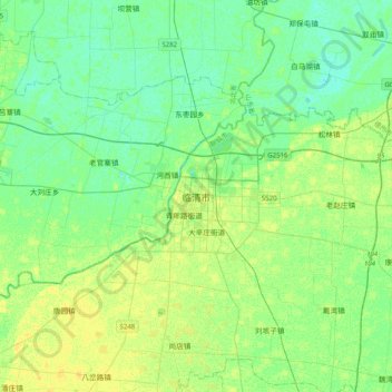
Name: 临清市 topographic map, elevation, terrain.
Location: 临清市, 聊城市, 山东省, 252600, 中国 (36.68592 115.55184 37.00592 115.87184)
Average elevation: 35 m
Minimum elevation: 28 m
Maximum elevation: 43 m
临清市地处黄河下游冲積平原,地势平坦,自西南向东北倾斜,海拔高度29—38米。由于受古黄泛影响,形成岗、坡、洼交错相间的微变地貌。
Other topographic maps
Click on a map to view its topography, its elevation and its terrain.