
Thank you for supporting this site ❤️
Make a donation
Make a donation
Sinar Agung topographic map
Click on the map to display elevation.
Thank you for supporting this site ❤️
Make a donation
Make a donation
About this map
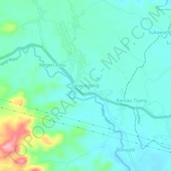
Name: Sinar Agung topographic map, elevation, terrain.
Location: Sinar Agung, Tanggamus, Lampung, Sumatra, Indonesia (-5.38148 104.83232 -5.34148 104.87232)
Average elevation: 167 m
Minimum elevation: 138 m
Maximum elevation: 281 m
Thank you for supporting this site ❤️
Make a donation
Make a donation
Other topographic maps
Click on a map to view its topography, its elevation and its terrain.