
Thank you for supporting this site ❤️
Make a donation
Make a donation
Mobile topographic map
Click on the map to display elevation.
Thank you for supporting this site ❤️
Make a donation
Make a donation
Mobile
According to the United States Census Bureau, the city has a total area of 180.1 square miles (466 km2), with 139.5 square miles (361 km2) of it being land, and 40.6 square miles (105.2 km2), or 22.5% of the total, being covered by water.[3] The elevation in Mobile ranges from 10 feet (3 m) on Water Street in downtown[4] to 211 feet (64 m) at the Mobile Regional Airport.[60]
Thank you for supporting this site ❤️
Make a donation
Make a donation
About this map
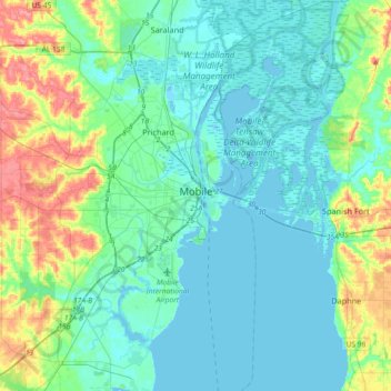
Name: Mobile topographic map, elevation, terrain.
Location: Mobile, Mobile County, Alabama, United States (30.56037 -88.22125 30.84346 -87.95662)
Average elevation: 18 m
Minimum elevation: -2 m
Maximum elevation: 82 m
Thank you for supporting this site ❤️
Make a donation
Make a donation