
Thank you for supporting this site ❤️
Make a donation
Make a donation
Villa Amancay topographic map
Click on the map to display elevation.
Thank you for supporting this site ❤️
Make a donation
Make a donation
About this map
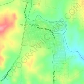
Name: Villa Amancay topographic map, elevation, terrain.
Average elevation: 603 m
Minimum elevation: 562 m
Maximum elevation: 695 m
Thank you for supporting this site ❤️
Make a donation
Make a donation
Other topographic maps
Click on a map to view its topography, its elevation and its terrain.
Santa Mónica
Argentina > Córdoba > Pedanía Santa Rosa > Santa Rosa de Calamuchita
Average elevation: 644 m