
Kakwa Mountain topographic map
Interactive map
Click on the map to display elevation.
About this map
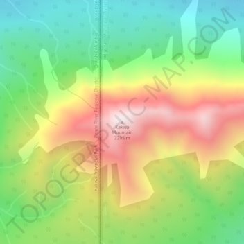
Name: Kakwa Mountain topographic map, elevation, terrain.
Average elevation: 1,787 m
Minimum elevation: 1,414 m
Maximum elevation: 2,278 m
Other topographic maps
Click on a map to view its topography, its elevation and its terrain.
Musreau Lake
Canada > Alberta > Municipal District of Greenview
Musreau Lake, Municipal District of Greenview, Alberta, Canada
Average elevation: 889 m
Little Smoky
Canada > Alberta > Municipal District of Greenview > Little Smoky
Little Smoky, Municipal District of Greenview, Alberta, Canada
Average elevation: 682 m
DeBolt
Canada > Alberta > Municipal District of Greenview
DeBolt, Municipal District of Greenview, Alberta, T0H 1B0, Canada
Average elevation: 644 m