
Holmes topographic map
Interactive map
Click on the map to display elevation.
About this map
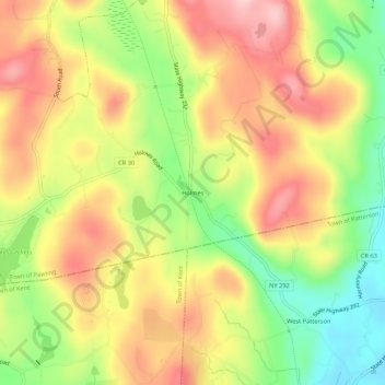
Name: Holmes topographic map, elevation, terrain.
Average elevation: 247 m
Minimum elevation: 137 m
Maximum elevation: 345 m
Other topographic maps
Click on a map to view its topography, its elevation and its terrain.
Shorehaven
United States > New York > Dutchess County > Town of Pawling
Shorehaven, Town of Pawling, Dutchess County, New York, United States
Average elevation: 292 m
Hurd Corners
United States > New York > Dutchess County > Town of Pawling
Hurd Corners, Town of Pawling, Dutchess County, New York, 12564, United States
Average elevation: 199 m