
Markt Rettenbach topographic map
Interactive map
Click on the map to display elevation.
About this map
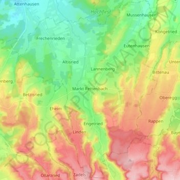
Name: Markt Rettenbach topographic map, elevation, terrain.
Average elevation: 702 m
Minimum elevation: 617 m
Maximum elevation: 817 m
Other topographic maps
Click on a map to view its topography, its elevation and its terrain.
Erisried
Deutschland > Bayern > Landkreis Unterallgäu
Erisried, Stetten, Dirlewang, Landkreis Unterallgäu, Bayern, 87778, Deutschland
Average elevation: 650 m
Lachen
Deutschland > Bayern > Landkreis Unterallgäu
Lachen, Memmingerberg, Landkreis Unterallgäu, Bayern, 87760, Deutschland
Average elevation: 653 m