
McMinnville topographic map
Interactive map
Click on the map to display elevation.
About this map
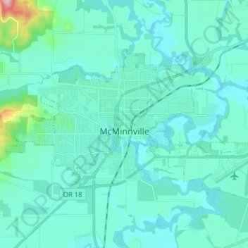
Name: McMinnville topographic map, elevation, terrain.
Location: McMinnville, Yamhill County, Oregon, 97128, United States (45.18565 -123.25450 45.23922 -123.12920)
Average elevation: 50 m
Minimum elevation: 25 m
Maximum elevation: 254 m
Other topographic maps
Click on a map to view its topography, its elevation and its terrain.
Newberg
United States > Oregon > Yamhill County
Newberg, Yamhill County, Oregon, United States
Average elevation: 61 m
Sheridan
United States > Oregon > Yamhill County
Sheridan, Yamhill County, Oregon, United States
Average elevation: 85 m
Lafayette
United States > Oregon > Yamhill County
Lafayette, Yamhill County, Oregon, 97127, United States
Average elevation: 52 m
McGuire Reservoir
United States > Oregon > Yamhill County
McGuire Reservoir, Yamhill County, Oregon, United States
Average elevation: 582 m
Bald Peak State Scenic Viewpoint
United States > Oregon > Yamhill County
Bald Peak State Scenic Viewpoint, Southwest Bald Peak Road, Yamhill County, Oregon, United States
Average elevation: 334 m
Carlton
United States > Oregon > Yamhill County
Carlton, Yamhill County, Oregon, 97111, United States
Average elevation: 51 m
Amity
United States > Oregon > Yamhill County
Amity, Yamhill County, Oregon, United States
Average elevation: 51 m
Dayton
United States > Oregon > Yamhill County
Dayton, Yamhill County, Oregon, United States
Average elevation: 43 m
Dundee
United States > Oregon > Yamhill County
Dundee, Yamhill County, Oregon, 97115, United States
Average elevation: 69 m
Willamina
United States > Oregon > Yamhill County > Willamina
Willamina, Yamhill County, Oregon, United States
Average elevation: 93 m
Yamhill
United States > Oregon > Yamhill County > Yamhill
Yamhill, Yamhill County, Oregon, United States
Average elevation: 55 m
Tetons
United States > Oregon > Yamhill County
Tetons, Yamhill County, Oregon, United States
Average elevation: 406 m