
New Shoreham topographic map
Interactive map
Click on the map to display elevation.
About this map
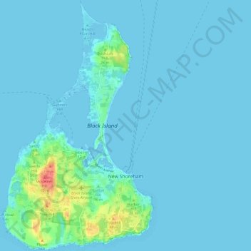
Name: New Shoreham topographic map, elevation, terrain.
Average elevation: 5 m
Minimum elevation: -3 m
Maximum elevation: 61 m
Other topographic maps
Click on a map to view its topography, its elevation and its terrain.
Rabbit Island
United States > Rhode Island > South County > North Kingstown > Wickford
Rabbit Island, Wickford, North Kingstown, South County, Rhode Island, United States
Average elevation: 10 m
Westerly
United States > Rhode Island > South County
Westerly, South County, Rhode Island, 02808, United States
Average elevation: 19 m
South Kingstown
United States > Rhode Island > South County
South Kingstown, South County, Rhode Island, United States
Average elevation: 30 m
Charlestown
United States > Rhode Island > South County
Charlestown, South County, Rhode Island, 02813, United States
Average elevation: 22 m
Wakefield
United States > Rhode Island > South County > South Kingstown
Wakefield, South Kingstown, South County, Rhode Island, 02879, United States
Average elevation: 23 m
Narragansett Town Beach
United States > Rhode Island > South County > Narragansett > Narragansett Pier
Narragansett Town Beach, Narragansett Beach, Narragansett Pier, Narragansett, South County, Rhode Island, United States
Average elevation: 6 m
Green Hill Point
United States > Rhode Island > South County > South Kingstown > Green Hill
Green Hill Point, Green Hill, South Kingstown, South County, Rhode Island, United States
Average elevation: 2 m
Block Island
United States > Rhode Island > South County > New Shoreham
Block Island, New Shoreham, South County, Rhode Island, 02807, United States
Average elevation: 5 m
Narragansett
United States > Rhode Island > South County
Narragansett, South County, Rhode Island, 02882, United States
Average elevation: 12 m
North Kingstown
United States > Rhode Island > South County
North Kingstown, South County, Rhode Island, United States
Average elevation: 35 m
Newton Swamp Management Area
United States > Rhode Island > South County > Westerly
Newton Swamp Management Area, McGowan Corners, Westerly, South County, Rhode Island, 02808, United States
Average elevation: 22 m
Kingston
United States > Rhode Island > South County
Kingston, South County, Rhode Island, 02881, United States
Average elevation: 47 m
Exeter
United States > Rhode Island > South County
Exeter, South County, Rhode Island, 02822, United States
Average elevation: 56 m
Ashaway
United States > Rhode Island > South County > Hopkinton > Ashaway
Ashaway, Hopkinton, South County, Rhode Island, 02804, United States
Average elevation: 31 m
Saunderstown
United States > Rhode Island > South County > North Kingstown
Saunderstown, North Kingstown, South County, Rhode Island, 02874, United States
Average elevation: 14 m
Hope Valley
United States > Rhode Island > South County > Hopkinton > Hope Valley
Hope Valley, Hopkinton, South County, Rhode Island, 02832, United States
Average elevation: 55 m
Hopkinton
United States > Rhode Island > South County
Hopkinton, South County, Rhode Island, United States
Average elevation: 63 m
Indian Lake
United States > Rhode Island > South County > South Kingstown
Indian Lake, South Kingstown, South County, Rhode Island, United States
Average elevation: 32 m
Wickford
United States > Rhode Island > South County > North Kingstown > Wickford
Wickford, North Kingstown, South County, Rhode Island, 02852, United States
Average elevation: 12 m
Matunuck
United States > Rhode Island > South County > South Kingstown
Matunuck, South Kingstown, South County, Rhode Island, United States
Average elevation: 5 m
Richmond
United States > Rhode Island > South County
Richmond, South County, Rhode Island, United States
Average elevation: 56 m