
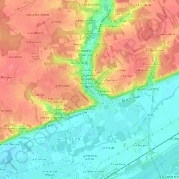
Les Bondes topographic map
Interactive map
Click on the map to display elevation.
About this map
Name: Les Bondes topographic map, elevation, terrain.
Average elevation: 84 m
Minimum elevation: 50 m
Maximum elevation: 116 m
Other topographic maps
Click on a map to view its topography, its elevation and its terrain.
Résidence du Lavoir
France > Centre-Val de Loire > Indre-et-Loire > Pocé-sur-Cisse
Résidence du Lavoir, Pocé-sur-Cisse, Loches, Indre-et-Loire, Centre-Val de Loire, France métropolitaine, 37530, France
Average elevation: 80 m
Les Fougerêts
France > Centre-Val de Loire > Indre-et-Loire > Pocé-sur-Cisse
Les Fougerêts, Pocé-sur-Cisse, Loches, Indre-et-Loire, Centre-Val de Loire, France métropolitaine, 37530, France
Average elevation: 71 m
Les Passages de Poce
France > Centre-Val de Loire > Indre-et-Loire > Pocé-sur-Cisse
Les Passages de Poce, Pocé-sur-Cisse, Loches, Indre-et-Loire, Centre-Val de Loire, France métropolitaine, 37530, France
Average elevation: 77 m
Clos du Potager
France > Centre-Val de Loire > Indre-et-Loire > Pocé-sur-Cisse
Clos du Potager, Pocé-sur-Cisse, Loches, Indre-et-Loire, Centre-Val de Loire, France métropolitaine, 37530, France
Average elevation: 80 m
Château de Launay
France > Centre-Val de Loire > Indre-et-Loire > Pocé-sur-Cisse > Château de Launay
Château de Launay, Pocé-sur-Cisse, Loches, Indre-et-Loire, Centre-Val de Loire, France métropolitaine, 37530, France
Average elevation: 81 m