
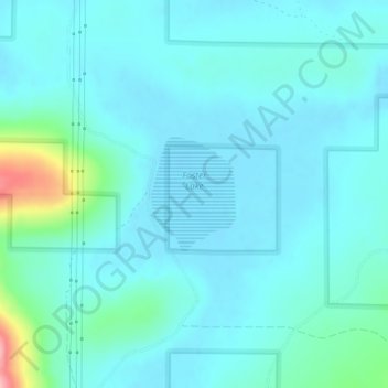
Foster Lake topographic map
Interactive map
Click on the map to display elevation.
About this map
Name: Foster Lake topographic map, elevation, terrain.
Location: Foster Lake, Lake County, Oregon, United States (42.94084 -120.95102 42.94888 -120.94293)
Average elevation: 1,816 m
Minimum elevation: 1,796 m
Maximum elevation: 1,937 m
Other topographic maps
Click on a map to view its topography, its elevation and its terrain.
Fort Rock
United States > Oregon > Lake County
Fort Rock, Lake County, Oregon, United States
Average elevation: 1,326 m
Christmas Valley
United States > Oregon > Lake County
Christmas Valley, Lake County, Oregon, 97641, United States
Average elevation: 1,316 m
Adel
United States > Oregon > Lake County
Adel, Lake County, Oregon, 97620, United States
Average elevation: 1,467 m
Green Creek
United States > Oregon > Lake County
Green Creek, Lake County, Oregon, United States
Average elevation: 1,657 m
Lakeview
United States > Oregon > Lake County
Lakeview, Lake County, Oregon, 97630, United States
Average elevation: 1,562 m