
Bulusan topographic map
Interactive map
Click on the map to display elevation.
About this map
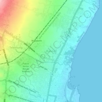
Name: Bulusan topographic map, elevation, terrain.
Location: Bulusan, Banyuwangi, East Java, 68421, Indonesia (-8.20867 114.35513 -8.16867 114.39513)
Average elevation: 36 m
Minimum elevation: -2 m
Maximum elevation: 149 m
Other topographic maps
Click on a map to view its topography, its elevation and its terrain.
Kertosari
Indonesia > East Java > Banyuwangi
Kertosari, Banyuwangi, East Java, 68418, Indonesia
Average elevation: 6 m
Tukangkayu
Indonesia > East Java > Banyuwangi
Tukangkayu, Banyuwangi, East Java, 68418, Indonesia
Average elevation: 14 m