
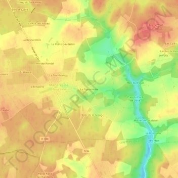
La Pigeonnière topographic map
Interactive map
Click on the map to display elevation.
About this map
Name: La Pigeonnière topographic map, elevation, terrain.
Average elevation: 91 m
Minimum elevation: 52 m
Maximum elevation: 111 m
Other topographic maps
Click on a map to view its topography, its elevation and its terrain.
Jupille
France > Centre-Val de Loire > Indre-et-Loire > Mazières-de-Touraine
Jupille, Mazières-de-Touraine, Chinon, Indre-et-Loire, Centre-Val de Loire, France métropolitaine, 37130, France
Average elevation: 96 m
Le Bourg
France > Centre-Val de Loire > Indre-et-Loire > Mazières-de-Touraine
Le Bourg, Mazières-de-Touraine, Chinon, Indre-et-Loire, Centre-Val de Loire, France métropolitaine, 37130, France
Average elevation: 92 m
La Gaudrière
France > Centre-Val de Loire > Indre-et-Loire > Mazières-de-Touraine
La Gaudrière, Mazières-de-Touraine, Chinon, Indre-et-Loire, Centre-Val de Loire, France métropolitaine, 37130, France
Average elevation: 91 m