
Thank you for supporting this site ❤️
Make a donation
Make a donation
Hermitage topographic map
Click on the map to display elevation.
Thank you for supporting this site ❤️
Make a donation
Make a donation
About this map
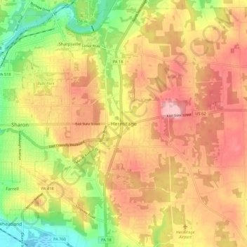
Name: Hermitage topographic map, elevation, terrain.
Location: Hermitage, Mercer County, Pennsylvania, 16148, United States (41.19339 -80.48868 41.27339 -80.40868)
Average elevation: 329 m
Minimum elevation: 250 m
Maximum elevation: 389 m
Thank you for supporting this site ❤️
Make a donation
Make a donation
Other topographic maps
Click on a map to view its topography, its elevation and its terrain.
Greenville
United States > Pennsylvania > Mercer County
Greenville is located in northwest Pennsylvania at 41°24′18″N 80°23′12″W / 41.40500°N 80.38667°W / 41.40500; -80.38667 (41.404998, −80.386651), along the Shenango River. Its altitude is 945 feet (288 m) above sea level.
Average elevation: 320 m
Thank you for supporting this site ❤️
Make a donation
Make a donation
Thank you for supporting this site ❤️
Make a donation
Make a donation
Thank you for supporting this site ❤️
Make a donation
Make a donation
Thank you for supporting this site ❤️
Make a donation
Make a donation