
Grady topographic map
Interactive map
Click on the map to display elevation.
About this map
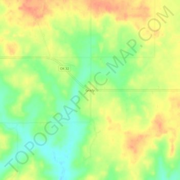
Name: Grady topographic map, elevation, terrain.
Location: Grady, Jefferson County, Oklahoma, United States (34.00038 -97.68558 34.04038 -97.64558)
Average elevation: 258 m
Minimum elevation: 233 m
Maximum elevation: 279 m
Other topographic maps
Click on a map to view its topography, its elevation and its terrain.
Ryan
United States > Oklahoma > Jefferson County
Ryan, Jefferson County, Oklahoma, 73565, United States
Average elevation: 267 m
Oscar
United States > Oklahoma > Jefferson County
Oscar, Jefferson County, Oklahoma, United States
Average elevation: 260 m
Petersburg
United States > Oklahoma > Jefferson County
Petersburg, Jefferson County, Oklahoma, United States
Average elevation: 251 m
Sugden
United States > Oklahoma > Jefferson County
Sugden, Jefferson County, Oklahoma, United States
Average elevation: 266 m
Cornish
United States > Oklahoma > Jefferson County
Cornish, Jefferson County, Oklahoma, United States
Average elevation: 263 m
Terral
United States > Oklahoma > Jefferson County
Terral, Jefferson County, Oklahoma, United States
Average elevation: 257 m
Ringling
United States > Oklahoma > Jefferson County
Ringling, Jefferson County, Oklahoma, 73456, United States
Average elevation: 270 m
Waurika
United States > Oklahoma > Jefferson County
Waurika, Jefferson County, Oklahoma, 73573, United States
Average elevation: 282 m