
Thank you for supporting this site ❤️
Make a donation
Make a donation
42551 topographic map
Click on the map to display elevation.
Thank you for supporting this site ❤️
Make a donation
Make a donation
About this map
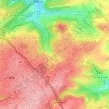
Name: 42551 topographic map, elevation, terrain.
Average elevation: 217 m
Minimum elevation: 129 m
Maximum elevation: 267 m
Thank you for supporting this site ❤️
Make a donation
Make a donation
Other topographic maps
Click on a map to view its topography, its elevation and its terrain.
Schloß Hardenberg
Deutschland > Nordrhein-Westfalen > Kreis Mettmann > Velbert > Schloß Hardenberg
Das Schloss wurde von der Familie von Gevertshagen (auch Gevertshain und Gebhardtshain geschrieben) als Wehrbau mit zugleich repräsentativen Aufgaben errichtet. Lange Zeit wurde dieses spätmittelalterliche Burghaus mit dem im Dezember 1354 urkundlich erwähnten „huis ind wohnunghe zue Hardenberg“ der…
Average elevation: 197 m
Thank you for supporting this site ❤️
Make a donation
Make a donation