
Paraná topographic map
Interactive map
Click on the map to display elevation.
About this map
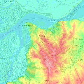
Name: Paraná topographic map, elevation, terrain.
Average elevation: 38 m
Minimum elevation: 6 m
Maximum elevation: 109 m
Other topographic maps
Click on a map to view its topography, its elevation and its terrain.
Oro Verde
Argentina > Entre Ríos > Distrito Sauce
Oro Verde, Distrito Sauce, Departamento Paraná, Entre Ríos, Argentina
Average elevation: 74 m
Junta de Gobierno de Sauce Montrull
Argentina > Entre Ríos > Distrito Sauce
Junta de Gobierno de Sauce Montrull, Distrito Sauce, Departamento Paraná, Entre Ríos, Argentina
Average elevation: 40 m
Oro Verde
Argentina > Entre Ríos > Distrito Sauce > Oro Verde
Oro Verde, Distrito Sauce, Departamento Paraná, Entre Ríos, Argentina
Average elevation: 78 m