
Ginzling topographic map
Interactive map
Click on the map to display elevation.
About this map
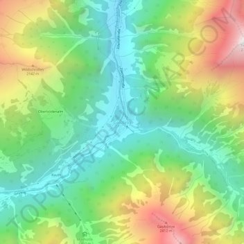
Name: Ginzling topographic map, elevation, terrain.
Location: Ginzling, Mayrhofen, Bezirk Schwaz, 6295, Österreich (47.08032 11.78904 47.12032 11.82904)
Average elevation: 1,564 m
Minimum elevation: 917 m
Maximum elevation: 2,710 m
Other topographic maps
Click on a map to view its topography, its elevation and its terrain.
Zemmgrund
Österreich > Bezirk Schwaz > Mayrhofen
Zemmgrund, Mayrhofen, Bezirk Schwaz, Österreich
Average elevation: 2,045 m