
Make a donation
Bad Essen topographic map
Click on the map to display elevation.
Make a donation
Bad Essen
The town of Bad Essen is on the North German Plains, because of the transition of the low mountain range to the plains. The Wiehengebirge Range covers approximately the southern third of the town and reaches an elevation of 211m above sea level. The highest point of the Wiehengebirge Range is on the black Brink in Lintorf. The northern part of the town is flat, with an average elevation of 50m above sea level. The Hunte flows through the eastern part of Bad Essen northwards and crosses the Midland Canal in Wittlage.
Make a donation
About this map
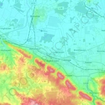
Name: Bad Essen topographic map, elevation, terrain.
Location: Bad Essen, Landkreis Osnabrück, Lower Saxony, 49152, Germany (52.27264 8.29056 52.38388 8.47077)
Average elevation: 79 m
Minimum elevation: 40 m
Maximum elevation: 203 m
Make a donation
Other topographic maps
Click on a map to view its topography, its elevation and its terrain.
Make a donation
Bad Essen
Germany > Lower Saxony > Landkreis Osnabrück > Bad Essen > Bad Essen
Average elevation: 85 m
Fürstenau
Germany > Lower Saxony > Landkreis Osnabrück > Fürstenau > Fürstenau
Average elevation: 54 m
Schwagstorf
Germany > Lower Saxony > Landkreis Osnabrück > Fürstenau > Schwagstorf
Average elevation: 84 m
Make a donation