
Steinach topographic map
Interactive map
Click on the map to display elevation.
About this map
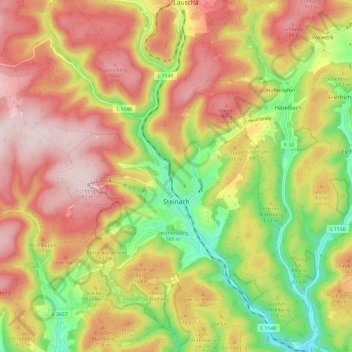
Name: Steinach topographic map, elevation, terrain.
Location: Steinach, Landkreis Sonneberg, Thuringia, 96523, Germany (50.39923 11.10861 50.47543 11.20282)
Average elevation: 653 m
Minimum elevation: 439 m
Maximum elevation: 838 m
Other topographic maps
Click on a map to view its topography, its elevation and its terrain.
Piesau
Germany > Thuringia > Landkreis Sonneberg > Neuhaus am Rennweg
Piesau, Neuhaus am Rennweg, Landkreis Sonneberg, Thuringia, Germany
Average elevation: 727 m