
Thank you for supporting this site ❤️
Make a donation
Make a donation
Calvert Hills topographic map
Click on the map to display elevation.
Thank you for supporting this site ❤️
Make a donation
Make a donation
About this map
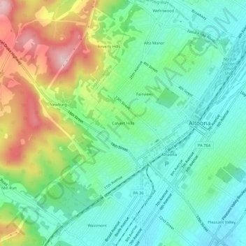
Name: Calvert Hills topographic map, elevation, terrain.
Average elevation: 412 m
Minimum elevation: 336 m
Maximum elevation: 569 m
Thank you for supporting this site ❤️
Make a donation
Make a donation
Other topographic maps
Click on a map to view its topography, its elevation and its terrain.
Mill Run
United States > Pennsylvania > Blair County > Altoona > Allegheny Furnace
Average elevation: 349 m