
Thank you for supporting this site ❤️
Make a donation
Make a donation
Atur topographic map
Click on the map to display elevation.
Thank you for supporting this site ❤️
Make a donation
Make a donation
About this map
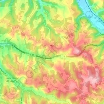
Name: Atur topographic map, elevation, terrain.
Average elevation: 192 m
Minimum elevation: 94 m
Maximum elevation: 275 m
Thank you for supporting this site ❤️
Make a donation
Make a donation
Other topographic maps
Click on a map to view its topography, its elevation and its terrain.
La Croix Bertrix
France > Nouvelle-Aquitaine > Dordogne > Boulazac Isle Manoire
Average elevation: 136 m
Thank you for supporting this site ❤️
Make a donation
Make a donation
Meyrinas
France > Nouvelle-Aquitaine > Dordogne > Boulazac Isle Manoire > Meyrinas
Average elevation: 172 m