
Château Saint-Jean topographic map
Interactive map
Click on the map to display elevation.
About this map
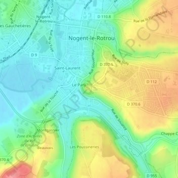
Name: Château Saint-Jean topographic map, elevation, terrain.
Average elevation: 133 m
Minimum elevation: 101 m
Maximum elevation: 187 m
Other topographic maps
Click on a map to view its topography, its elevation and its terrain.
Plateau Saint-Jean
France > Centre-Val de Loire > Nogent-le-Rotrou
Plateau Saint-Jean, Nogent-le-Rotrou, Eure-et-Loir, Centre-Val de Loire, France métropolitaine, 28400, France
Average elevation: 144 m