
Rocky Butte topographic map
Interactive map
Click on the map to display elevation.
About this map
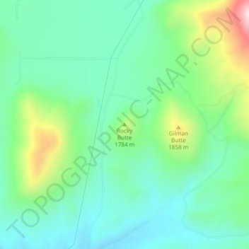
Name: Rocky Butte topographic map, elevation, terrain.
Location: Rocky Butte, Blaine County, Idaho, United States (43.45569 -114.37621 43.45579 -114.37611)
Average elevation: 1,727 m
Minimum elevation: 1,616 m
Maximum elevation: 2,018 m
Other topographic maps
Click on a map to view its topography, its elevation and its terrain.
Sawtooth City
United States > Idaho > Blaine County
Sawtooth City, Blaine County, Idaho, United States
Average elevation: 2,219 m
Carey
United States > Idaho > Blaine County
Carey, Blaine County, Idaho, 83320, United States
Average elevation: 1,467 m
Sun Valley
United States > Idaho > Blaine County
Sun Valley, Blaine County, Idaho, United States
Average elevation: 1,988 m
Ketchum
United States > Idaho > Blaine County
Ketchum, Blaine County, Idaho, United States
Average elevation: 1,906 m
Titus Lake
United States > Idaho > Blaine County
Titus Lake, Blaine County, Idaho, United States
Average elevation: 2,736 m
Bellevue
United States > Idaho > Blaine County
Bellevue, Blaine County, Idaho, 83313, United States
Average elevation: 1,667 m
Hailey
United States > Idaho > Blaine County
Hailey, Blaine County, Idaho, 83333, United States
Average elevation: 1,729 m