
Ormoc topographic map
Interactive map
Click on the map to display elevation.
About this map
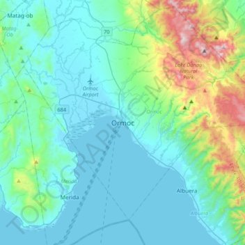
Name: Ormoc topographic map, elevation, terrain.
Average elevation: 201 m
Minimum elevation: 0 m
Maximum elevation: 1,204 m
Other topographic maps
Click on a map to view its topography, its elevation and its terrain.
Green Valley
Philippines > Leyte > Ormoc
Green Valley, Ormoc, 4th District, Leyte, Eastern Visayas, 6541, Philippines
Average elevation: 81 m
Cagbuhangin
Philippines > Leyte > Ormoc
Cagbuhangin, Ormoc, 4th District, Leyte, Eastern Visayas, 6541, Philippines
Average elevation: 66 m
Lake Danao
Philippines > Leyte > Ormoc
Lake Danao, Ormoc, Leyte 4th District, Leyte, Eastern Visayas, 6541, Philippines
Average elevation: 729 m
Binahaan River
Philippines > Leyte > Ormoc
Binahaan River, Ormoc, Leyte 4th District, Leyte, Eastern Visayas, 6541, Philippines
Average elevation: 516 m
Malbasag River
Philippines > Leyte > Ormoc
Malbasag River, Ormoc, Leyte 4th District, Leyte, Eastern Visayas, 6541, Philippines
Average elevation: 200 m
Pagsangahan River
Philippines > Leyte > Ormoc
Pagsangahan River, Ormoc, Leyte 4th District, Leyte, Eastern Visayas, 6541, Philippines
Average elevation: 2 m
Anilao River
Philippines > Leyte > Ormoc
Anilao River, Ormoc, Leyte 4th District, Leyte, Eastern Visayas, 6541, Philippines
Average elevation: 80 m
Cambantog
Philippines > Leyte > Ormoc > Cambantog
Cambantog, Ormoc, Leyte 4th District, Leyte, Eastern Visayas, 6541, Philippines
Average elevation: 729 m