
Thank you for supporting this site ❤️
Make a donation
Make a donation
Saint-Rambert topographic map
Click on the map to display elevation.
Thank you for supporting this site ❤️
Make a donation
Make a donation
About this map
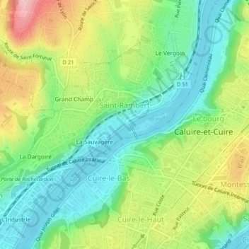
Name: Saint-Rambert topographic map, elevation, terrain.
Average elevation: 224 m
Minimum elevation: 163 m
Maximum elevation: 325 m
Thank you for supporting this site ❤️
Make a donation
Make a donation
Other topographic maps
Click on a map to view its topography, its elevation and its terrain.
Parc de la Tête d'Or
France > Auvergne-Rhône-Alpes > Métropole de Lyon > Lyon
Average elevation: 189 m
Jardin Guylaine Gouzou-Testud
France > Auvergne-Rhône-Alpes > Métropole de Lyon > Lyon
Average elevation: 211 m
Thank you for supporting this site ❤️
Make a donation
Make a donation