
Thank you for supporting this site ❤️
Make a donation
Make a donation
Santa Catarina topographic map
Click on the map to display elevation.
Thank you for supporting this site ❤️
Make a donation
Make a donation
Santa Catarina
The highest point of the state is the Morro da Boa Vista, at an altitude of 1,827 m, and the second-highest point is the Morro da Igreja, in the town of Urubici, at an altitude of 1,822 m.
Thank you for supporting this site ❤️
Make a donation
Make a donation
About this map
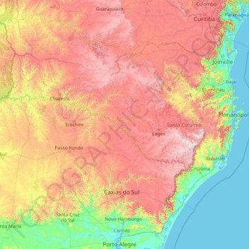
Name: Santa Catarina topographic map, elevation, terrain.
Location: Santa Catarina, South Region, Brazil (-29.44091 -53.83735 -25.95572 -48.10211)
Average elevation: 530 m
Minimum elevation: -3 m
Maximum elevation: 1,778 m
Thank you for supporting this site ❤️
Make a donation
Make a donation
Other topographic maps
Click on a map to view its topography, its elevation and its terrain.