
Yonne topographic map
Interactive map
Click on the map to display elevation.
About this map
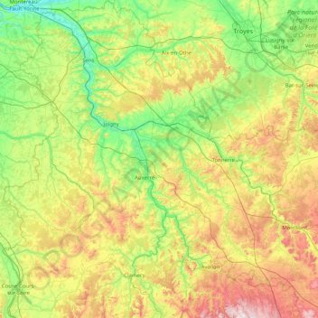
Name: Yonne topographic map, elevation, terrain.
Location: Yonne, Bourgogne-Franche-Comté, Metropolitan France, France (47.31036 2.84849 48.40006 4.34007)
Average elevation: 207 m
Minimum elevation: 45 m
Maximum elevation: 623 m
Other topographic maps
Click on a map to view its topography, its elevation and its terrain.
Doubs
France > Bourgogne-Franche-Comté
Doubs, Bourgogne-Franche-Comté, Metropolitan France, France
Average elevation: 572 m
Crain
France > Bourgogne-Franche-Comté > Yonne
Crain, Auxerre, Yonne, Bourgogne-Franche-Comté, Metropolitan France, 89480, France
Average elevation: 179 m
Nantoux
France > Bourgogne-Franche-Comté > Côte-d'Or
Nantoux, Beaune, Côte-d'Or, Bourgogne-Franche-Comté, Metropolitan France, 21190, France
Average elevation: 374 m
Montbéliard
France > Bourgogne-Franche-Comté > Doubs
Montbéliard, Doubs, Bourgogne-Franche-Comté, Metropolitan France, 25200, France
Average elevation: 350 m
Bellefontaine
France > Bourgogne-Franche-Comté > Bellefontaine
Bellefontaine, Saint-Claude, Jura, Bourgogne-Franche-Comté, Metropolitan France, 39400, France
Average elevation: 1,100 m
Ville-du-Pont
France > Bourgogne-Franche-Comté > Ville-du-Pont
Ville-du-Pont, Pontarlier, Doubs, Bourgogne-Franche-Comté, Metropolitan France, 25650, France
Average elevation: 928 m
Lons-le-Saunier
France > Bourgogne-Franche-Comté > Lons-le-Saunier
Lons-le-Saunier, Jura, Bourgogne-Franche-Comté, Metropolitan France, 39000, France
Average elevation: 303 m
Meursault
France > Bourgogne-Franche-Comté > Meursault
Meursault, Beaune, Côte-d'Or, Bourgogne-Franche-Comté, Metropolitan France, 21190, France
Average elevation: 267 m
Les Plates
France > Bourgogne-Franche-Comté > Les Plates
Les Plates, Louhans, Saône-et-Loire, Bourgogne-Franche-Comté, Metropolitan France, France
Average elevation: 204 m
Neuilly-Crimolois
France > Bourgogne-Franche-Comté > Neuilly-Crimolois
Neuilly-Crimolois, Dijon, Côte-d'Or, Bourgogne-Franche-Comté, Metropolitan France, 21800, France
Average elevation: 218 m
Besançon
France > Bourgogne-Franche-Comté > Besançon
Besançon, Doubs, Bourgogne-Franche-Comté, Metropolitan France, 25000, France
Average elevation: 332 m
Brèves
France > Bourgogne-Franche-Comté > Brèves
Brèves, Clamecy, Nièvre, Bourgogne-Franche-Comté, Metropolitan France, 58530, France
Average elevation: 221 m
Nièvre
France > Bourgogne-Franche-Comté
Nièvre, Bourgogne-Franche-Comté, Metropolitan France, France
Average elevation: 284 m
Les Molunes
France > Bourgogne-Franche-Comté > Les Crottes
Les Molunes, Les Crottes, Saint-Claude, Jura, Bourgogne-Franche-Comté, Metropolitan France, 39310, France
Average elevation: 1,185 m
En Pierrelay
France > Bourgogne-Franche-Comté > En Pierrelay
En Pierrelay, Mâcon, Saône-et-Loire, Bourgogne-Franche-Comté, Metropolitan France, 71520, France
Average elevation: 467 m
La Rochepot
France > Bourgogne-Franche-Comté > La Rochepot
La Rochepot, Beaune, Côte-d'Or, Bourgogne-Franche-Comté, Metropolitan France, 21340, France
Average elevation: 427 m
Épenoy
France > Bourgogne-Franche-Comté > Épenoy
Épenoy, Pontarlier, Doubs, Bourgogne-Franche-Comté, Metropolitan France, 25800, France
Average elevation: 721 m
Ronchamp
France > Bourgogne-Franche-Comté > Ronchamp
Ronchamp, Lure, Haute-Saône, Bourgogne-Franche-Comté, Metropolitan France, 70250, France
Average elevation: 444 m
Jura Mountains Regional Natural Park
France > Bourgogne-Franche-Comté > Longchaumois
Jura Mountains Regional Natural Park, D 69E1, Sur le Villard, Longchaumois, Saint-Claude, Jura, Bourgogne-Franche-Comté, Metropolitan France, 39400, France
Average elevation: 691 m
Baume-les-Messieurs
France > Bourgogne-Franche-Comté > Baume-les-Messieurs
Baume-les-Messieurs, Lons-le-Saunier, Jura, Bourgogne-Franche-Comté, Metropolitan France, 39210, France
Average elevation: 480 m