
Thank you for supporting this site ❤️
Make a donation
Make a donation
Valdes Peninsula topographic map
Click on the map to display elevation.
Thank you for supporting this site ❤️
Make a donation
Make a donation
Valdes Peninsula
Most of the peninsula is barren land with some salt lakes. The largest of these lakes is at an elevation of about 40 m below sea level (see extremes on Earth), until recently thought to be the lowest elevation in Argentina and South America (the lowest point actually being Laguna del Carbón, Argentina).
Thank you for supporting this site ❤️
Make a donation
Make a donation
About this map
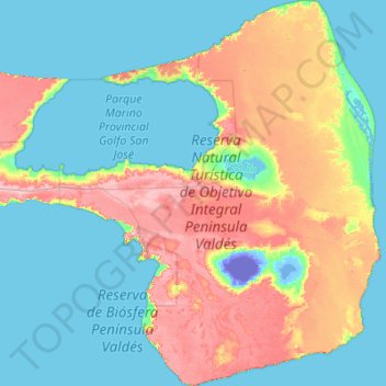
Name: Valdes Peninsula topographic map, elevation, terrain.
Location: Valdes Peninsula, Chubut, SIN DATO, Argentina (-42.87900 -64.62156 -42.07170 -63.58324)
Average elevation: 28 m
Minimum elevation: -43 m
Maximum elevation: 106 m
Thank you for supporting this site ❤️
Make a donation
Make a donation