
Thank you for supporting this site ❤️
Make a donation
Make a donation
Le Temple topographic map
Click on the map to display elevation.
Thank you for supporting this site ❤️
Make a donation
Make a donation
About this map
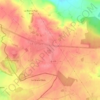
Name: Le Temple topographic map, elevation, terrain.
Average elevation: 203 m
Minimum elevation: 144 m
Maximum elevation: 226 m
Thank you for supporting this site ❤️
Make a donation
Make a donation
Other topographic maps
Click on a map to view its topography, its elevation and its terrain.
Zone industrielle de la Poterie
France > Nouvelle-Aquitaine > Deux-Sèvres > Mauléon
Average elevation: 170 m