
Glenbrook topographic map
Interactive map
Click on the map to display elevation.
About this map
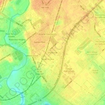
Name: Glenbrook topographic map, elevation, terrain.
Average elevation: 201 m
Minimum elevation: 177 m
Maximum elevation: 213 m
Other topographic maps
Click on a map to view its topography, its elevation and its terrain.
Rivercrest Heights
United States > Texas > Comal County > New Braunfels
Rivercrest Heights, New Braunfels, Comal County, Texas, 78130, United States
Average elevation: 202 m
Oak Run
United States > Texas > Comal County > New Braunfels
Oak Run, New Braunfels, Comal County, Texas, 78132, United States
Average elevation: 254 m
Woodrow
United States > Texas > Comal County > New Braunfels
Woodrow, New Braunfels, Comal County, Texas, 78130, United States
Average elevation: 219 m
Gruene
United States > Texas > Comal County > New Braunfels
Gruene, New Braunfels, Comal County, Texas, 78135, United States
Average elevation: 210 m
Thorn Hill
United States > Texas > Comal County > New Braunfels
Thorn Hill, New Braunfels, Comal County, Texas, 78135, United States
Average elevation: 213 m
Freiheit
United States > Texas > Comal County > New Braunfels
Freiheit, New Braunfels, Comal County, Texas, 78135, United States
Average elevation: 204 m
Summerwood
United States > Texas > Comal County > New Braunfels > Summerwood
Summerwood, New Braunfels, Comal County, Texas, 78130, United States
Average elevation: 200 m