
Landershofen topographic map
Interactive map
Click on the map to display elevation.
About this map
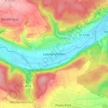
Name: Landershofen topographic map, elevation, terrain.
Average elevation: 456 m
Minimum elevation: 381 m
Maximum elevation: 529 m
Other topographic maps
Click on a map to view its topography, its elevation and its terrain.
Hofmühle
Deutschland > Bayern > Landkreis Eichstätt > Eichstätt > Rebdorf
Hofmühle, Rebdorf, Eichstätt, Landkreis Eichstätt, Bayern, 85072, Deutschland
Average elevation: 475 m
Rebdorf
Deutschland > Bayern > Landkreis Eichstätt > Eichstätt
Rebdorf, Eichstätt, Landkreis Eichstätt, Bayern, 85072, Deutschland
Average elevation: 472 m