
Thank you for supporting this site ❤️
Make a donation
Make a donation
Recinto Santa Lucía topographic map
Click on the map to display elevation.
Thank you for supporting this site ❤️
Make a donation
Make a donation
About this map
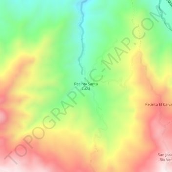
Name: Recinto Santa Lucía topographic map, elevation, terrain.
Location: Recinto Santa Lucía, Echeandía, Bolívar, Ecuador (-1.49658 -79.24624 -1.45658 -79.20624)
Average elevation: 871 m
Minimum elevation: 511 m
Maximum elevation: 1,266 m
Thank you for supporting this site ❤️
Make a donation
Make a donation