
Chadouillet topographic map
Interactive map
Click on the map to display elevation.
About this map
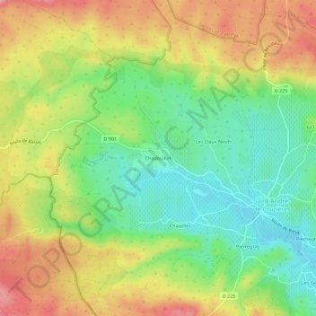
Name: Chadouillet topographic map, elevation, terrain.
Average elevation: 211 m
Minimum elevation: 152 m
Maximum elevation: 281 m
Other topographic maps
Click on a map to view its topography, its elevation and its terrain.
Pierregras
Frankrijk > Auvergne-Rhône-Alpes > Ardèche > Saint-André-de-Cruzières
Pierregras, Saint-André-de-Cruzières, Largentière, Ardèche, Auvergne-Rhône-Alpes, Metropolitaans Frankrijk, 07460, Frankrijk
Average elevation: 215 m