
Randolph Township topographic map
Interactive map
Click on the map to display elevation.
About this map
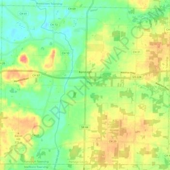
Name: Randolph Township topographic map, elevation, terrain.
Average elevation: 353 m
Minimum elevation: 326 m
Maximum elevation: 387 m
Other topographic maps
Click on a map to view its topography, its elevation and its terrain.
Windham Township
United States > Ohio > Portage County
Windham Township, Portage County, Ohio, United States
Average elevation: 315 m
Aurora
United States > Ohio > Portage County
Aurora, Portage County, Ohio, 44202, United States
Average elevation: 335 m
Kent
United States > Ohio > Portage County > Kent > Kent
Kent, Portage County, Ohio, 44240, United States
Average elevation: 329 m
Atwater
United States > Ohio > Portage County > Atwater
Atwater, Atwater Township, Portage County, Ohio, United States
Average elevation: 346 m
Kent
United States > Ohio > Portage County
Kent, Portage County, Ohio, United States
Average elevation: 328 m
Streetsboro
United States > Ohio > Portage County
Streetsboro, Portage County, Ohio, 44241, United States
Average elevation: 335 m