
La Grosse Chaintre topographic map
Interactive map
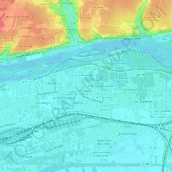
Click on the map to display elevation.
About this map
Name: La Grosse Chaintre topographic map, elevation, terrain.
Average elevation: 61 m
Minimum elevation: 44 m
Maximum elevation: 114 m
Other topographic maps
Click on a map to view its topography, its elevation and its terrain.
Les Coutures
France > Centre-Val de Loire > Indre-et-Loire > La Ville-aux-Dames
Les Coutures, La Ville-aux-Dames, Tours, Indre-et-Loire, Centre-Val de Loire, France métropolitaine, 37700, France
Average elevation: 57 m
Le Grand Village
France > Centre-Val de Loire > Indre-et-Loire > La Ville-aux-Dames
Le Grand Village, La Ville-aux-Dames, Arrondissement de Tours, Indre-et-Loire, Centre-Val de Loire, France métropolitaine, 37700, France
Average elevation: 51 m
Le Pré Change
France > Centre-Val de Loire > Indre-et-Loire > La Ville-aux-Dames
Le Pré Change, La Ville-aux-Dames, Arrondissement de Tours, Indre-et-Loire, Centre-Val de Loire, France métropolitaine, 37700, France
Average elevation: 61 m
Champfleuri
France > Centre-Val de Loire > Indre-et-Loire > La Ville-aux-Dames
Champfleuri, La Ville-aux-Dames, Tours, Indre-et-Loire, Centre-Val de Loire, France métropolitaine, 37700, France
Average elevation: 59 m
Les Maisons Brûlées
France > Centre-Val de Loire > Indre-et-Loire > La Ville-aux-Dames > Les Maisons Brûlées
Les Maisons Brûlées, La Ville-aux-Dames, Tours, Indre-et-Loire, Centre-Val de Loire, France métropolitaine, 37700, France
Average elevation: 51 m