
Thank you for supporting this site ❤️
Make a donation
Make a donation
Dryden Farm topographic map
Click on the map to display elevation.
Thank you for supporting this site ❤️
Make a donation
Make a donation
About this map
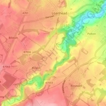
Name: Dryden Farm topographic map, elevation, terrain.
Average elevation: 144 m
Minimum elevation: 63 m
Maximum elevation: 187 m
Thank you for supporting this site ❤️
Make a donation
Make a donation
Other topographic maps
Click on a map to view its topography, its elevation and its terrain.
Straiton Pond Local Nature Reserve
United Kingdom > Scotland > Midlothian > Loanhead
Average elevation: 131 m