
Thank you for supporting this site ❤️
Make a donation
Make a donation
Belfair topographic map
Click on the map to display elevation.
Thank you for supporting this site ❤️
Make a donation
Make a donation
About this map
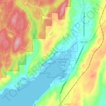
Name: Belfair topographic map, elevation, terrain.
Location: Belfair, Mason County, Washington, United States (47.41664 -122.88748 47.47625 -122.80076)
Average elevation: 65 m
Minimum elevation: -2 m
Maximum elevation: 162 m
Thank you for supporting this site ❤️
Make a donation
Make a donation
Other topographic maps
Click on a map to view its topography, its elevation and its terrain.
Mount Ellinor
United States > Washington > Mason County
Mount Ellinor is a peak in the Olympic Mountains of Washington, United States. It is located in an area designated as the Mount Skokomish Wilderness. The mountain is a popular day hike in the summer months; the summit is reachable via a steep-but-brief 3.3-mile (5.3 km) trail which gains about 3,200 feet (980…
Average elevation: 1,334 m
Thank you for supporting this site ❤️
Make a donation
Make a donation
Thank you for supporting this site ❤️
Make a donation
Make a donation
Thank you for supporting this site ❤️
Make a donation
Make a donation