
Thank you for supporting this site ❤️
Make a donation
Make a donation
Frannie topographic map
Click on the map to display elevation.
Thank you for supporting this site ❤️
Make a donation
Make a donation
About this map
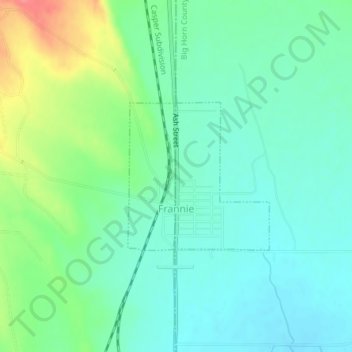
Name: Frannie topographic map, elevation, terrain.
Location: Frannie, Big Horn County, Wyoming, 82423, United States (44.96592 -108.62677 44.97729 -108.61141)
Average elevation: 1,292 m
Minimum elevation: 1,271 m
Maximum elevation: 1,344 m
Thank you for supporting this site ❤️
Make a donation
Make a donation
Other topographic maps
Click on a map to view its topography, its elevation and its terrain.