
Thank you for supporting this site ❤️
Make a donation
Make a donation
Doi Hang topographic map
Click on the map to display elevation.
Thank you for supporting this site ❤️
Make a donation
Make a donation
About this map
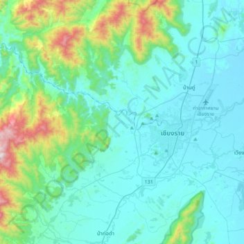
Name: Doi Hang topographic map, elevation, terrain.
Location: Doi Hang, Chiang Rai Province, Thailand (19.76120 99.60285 20.08120 99.92285)
Average elevation: 556 m
Minimum elevation: 381 m
Maximum elevation: 1,504 m
Thank you for supporting this site ❤️
Make a donation
Make a donation
Other topographic maps
Click on a map to view its topography, its elevation and its terrain.