
Make a donation
Pucheng County topographic map
Click on the map to display elevation.
Make a donation
About this map
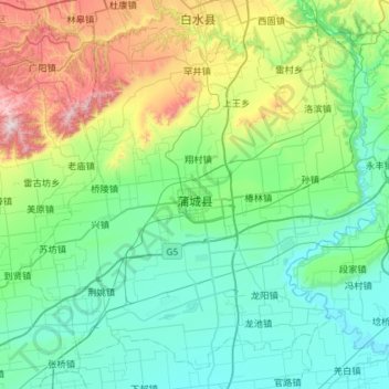
Name: Pucheng County topographic map, elevation, terrain.
Location: Pucheng County, Weinan City, Shaanxi, China (34.74845 109.33758 35.17660 109.91815)
Average elevation: 554 m
Minimum elevation: 342 m
Maximum elevation: 1,355 m
Make a donation
Other topographic maps
Click on a map to view its topography, its elevation and its terrain.
Xi'an
China > Shaanxi > Weiyang District > Xi'an
Xi'an lies on the Guanzhong Plain in the south-central part of Shaanxi province, on a flood plain created by the eight surrounding rivers and streams. The city has an average elevation of 400 metres (1,312 ft) above sea level and an annual precipitation of 553 mm (21.8 in). The urban area of Xi'an is located…
Average elevation: 412 m
Make a donation
Huanglong
Huanglong County is located approximately 221 kilometres (137 mi) from Yan'an's urban core, and 226 kilometres (140 mi) from Xi'an's urban core. Located in the Loess Plateau, Huanglong County is hilly in elevation, ranging from 643.7 metres (2,112 ft) to 1,738 metres (5,702 ft) in height. A number of minor…
Average elevation: 1,348 m
Make a donation
Make a donation