
Thank you for supporting this site ❤️
Make a donation
Make a donation
Moyon topographic map
Click on the map to display elevation.
Thank you for supporting this site ❤️
Make a donation
Make a donation
About this map
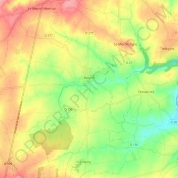
Name: Moyon topographic map, elevation, terrain.
Average elevation: 100 m
Minimum elevation: 35 m
Maximum elevation: 166 m
Thank you for supporting this site ❤️
Make a donation
Make a donation
Other topographic maps
Click on a map to view its topography, its elevation and its terrain.
Village Montigny
France > Normandie > Manche > Moyon Villages > Moyon > Village Montigny
Average elevation: 116 m