
Thank you for supporting this site ❤️
Make a donation
Make a donation
Accous topographic map
Click on the map to display elevation.
Thank you for supporting this site ❤️
Make a donation
Make a donation
About this map
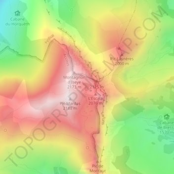
Name: Accous topographic map, elevation, terrain.
Average elevation: 1,771 m
Minimum elevation: 1,323 m
Maximum elevation: 2,166 m
Thank you for supporting this site ❤️
Make a donation
Make a donation
Other topographic maps
Click on a map to view its topography, its elevation and its terrain.
Bayonne
France > Nouvelle-Aquitaine > Pyrénées-Atlantiques
In the late Quaternary, the current topographic physiognomy was formed—i.e. a set of hills overlooking a swampy lowland. The promontory of Bassussarry–Marracq ultimately extended to the Labourdin foothills. The Grand Bayonne hill is an example. Similarly, on the right bank of the Nive, the heights of…
Average elevation: 23 m
Thank you for supporting this site ❤️
Make a donation
Make a donation