
Make a donation
Quisapincha topographic map
Click on the map to display elevation.
Make a donation
Quisapincha
The town has once been the center of Kisapincha resistance against Spanish and Creole intruders. Many of the Kisapincha now live in the high altitude communities that form Quisapincha Alto, part of the parroquia of Quisapincha. The only footpaths connecting Quisapincha Alto with larger cities were constantly watched and could be easily blocked by the defenders. Locals remember that "until 1975 no white man could enter Quisapincha Alto. It was impossible." The parroquia of Quisapincha once had infant mortality of 547 deaths per 1000 births, and the communities of Quisapincha Alto are now growing at 6.3% per annum. During the 1992 uprising the indigenous people of Quisapincha Alto reappropriated the land from the church and gained some Kisapincha representation in local politics. Their rule faces continuing opposition from mestizo townspeople.
Make a donation
About this map
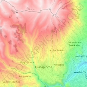
Name: Quisapincha topographic map, elevation, terrain.
Location: Quisapincha, Ambato, Tungurahua, Ecuador (-1.26499 -78.78253 -1.13240 -78.65199)
Average elevation: 3,413 m
Minimum elevation: 2,481 m
Maximum elevation: 4,179 m
Make a donation
Other topographic maps
Click on a map to view its topography, its elevation and its terrain.