
Thank you for supporting this site ❤️
Make a donation
Make a donation
Gil Island topographic map
Click on the map to display elevation.
Thank you for supporting this site ❤️
Make a donation
Make a donation
About this map
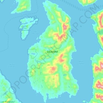
Name: Gil Island topographic map, elevation, terrain.
Average elevation: 88 m
Minimum elevation: 0 m
Maximum elevation: 974 m
Thank you for supporting this site ❤️
Make a donation
Make a donation
Other topographic maps
Click on a map to view its topography, its elevation and its terrain.
Denarta Park
Canada > British Columbia > Regional District of Kitimat-Stikine > Area C (Butedale/Kitlope/Kitsumkalum)
Average elevation: 155 m
Kitnayakwa River
Canada > British Columbia > Regional District of Kitimat-Stikine > Area C (Butedale/Kitlope/Kitsumkalum)
Average elevation: 536 m