
衡山 topographic map
Interactive map
Click on the map to display elevation.
About this map
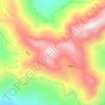
Name: 衡山 topographic map, elevation, terrain.
Location: 衡山, 南岳镇, 南岳区, 衡阳市, 湖南省, 中国 (27.27791 112.67542 27.27801 112.67552)
Average elevation: 856 m
Minimum elevation: 515 m
Maximum elevation: 1,120 m
衡山山脉位于湖南省中部偏东南,南起衡阳白露坳,北止长沙城西,长约80公里。关于衡山旧有南岳“七十二峰”之说,称回雁为首,岳麓为足。衡山山脉属华夏及华夏式构造体系,由燕山期花岗岩构成断块山体。因经历长期侵蚀,成为准平原;第三纪末新构造运动,花岗岩地层上升断裂成今貌。衡山山脉最高峰为祝融峰海拔1300.2米。